


Revolutionizing Road Maintenance: Autonomous Vehicles as Infrastructure Sentinels
In a significant development for urban infrastructure and autonomous technology, Waymo robotaxis are now being deployed in a novel capacity: to proactively identify and report potholes to city transportation departments. This initiative, stemming from a collaboration with Waze, the widely utilized navigation and traffic data provider, promises to transform how municipalities detect and address road damage, paving the way for safer and more efficient urban environments.
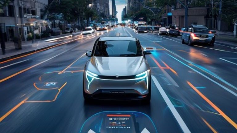
The concept is elegantly simple yet powerfully impactful. Waymo, a leader in autonomous driving technology, operates fleets of self-driving vehicles that constantly traverse city streets. These vehicles are equipped with an array of sophisticated sensors, including high-resolution cameras, lidar, and radar systems, all of which meticulously map their surroundings for navigation and obstacle detection. The partnership leverages this existing technological capability, transforming each Waymo robotaxi into a mobile road inspection unit. As these vehicles navigate their routes, their advanced sensor suites can identify anomalies in the road surface, such as the characteristic dips and edges of a pothole.
Once detected, this critical information is relayed through Waze, a platform renowned for its community-driven approach to real-time traffic and road condition reporting. Waze’s established network and interface provide an efficient conduit for transmitting these pothole alerts directly to the relevant city transportation departments. This integration streamlines the process, moving from a reactive model, where citizens or municipal workers manually report issues, to a more proactive and automated system. The accuracy and frequency of data collection inherent in autonomous operations offer a level of detail and immediacy previously unattainable, enabling cities to respond to infrastructure degradation with unprecedented speed and precision.
The Mechanics of Detection: How Robotaxis Spot Road Imperfections
The ability of Waymo robotaxis to detect potholes relies on the same sophisticated technology that allows them to drive safely and autonomously. Their sensor arrays are designed to create a detailed, three-dimensional understanding of the environment. Cameras capture visual data, lidar sensors emit laser pulses to measure distances and create detailed point clouds of the surroundings, and radar systems detect objects and their velocity. When a vehicle encounters a pothole, this complex interplay of sensors registers a deviation from a smooth, level road surface. For instance, lidar can precisely map the depth and dimensions of a depression, while cameras can capture visual evidence. Furthermore, onboard accelerometers and gyroscopes can detect sudden vertical movements or jolts that are characteristic of driving over damaged pavement. This multi-modal sensing approach ensures a high degree of accuracy in identifying and characterizing road imperfections.
The data collected is not just raw sensor output. It is processed by Waymo’s onboard computing systems, which utilize artificial intelligence and machine learning algorithms to identify and classify objects and conditions in real-time. These algorithms, trained on vast datasets, can distinguish between various road features and anomalies, including potholes, cracks, manhole covers, and other surface irregularities. This intelligent processing is crucial for filtering out false positives and ensuring that only relevant, actionable information is transmitted. The integration with Waze then acts as the crucial bridge, translating this highly technical data into a format that can be effectively utilized by municipal maintenance crews.
Transformative Benefits for Urban Infrastructure and Safety
The implications of this partnership extend far beyond simply locating potholes; they touch upon the core aspects of urban living and infrastructure management. Here are some key benefits:
- Enhanced Road Safety: Potholes are a significant road hazard, contributing to accidents, particularly for motorcyclists and cyclists, and sudden maneuvers that can lead to collisions for all vehicles. Proactive detection and repair reduce these risks, making streets safer for everyone.
- Reduced Vehicle Damage and Maintenance Costs: Driving over potholes repeatedly can cause considerable damage to vehicle tires, wheels, suspension systems, and alignment. By facilitating quicker repairs, this initiative can help vehicle owners save on costly maintenance and repairs.
- Proactive Maintenance and Budget Efficiency: Instead of waiting for citizen complaints or reactive repairs, cities can adopt a more proactive maintenance schedule. This allows for better resource allocation, preventing small issues from escalating into larger, more expensive problems, and potentially extending the overall lifespan of road surfaces.
- Improved Traffic Flow: Roads riddled with potholes often force drivers to swerve or slow down significantly, leading to traffic bottlenecks and delays. Smoother roads contribute to more consistent traffic flow and reduced commuting times.
- Data-Driven Urban Planning: The granular data collected by Waymo robotaxis, aggregated through Waze, can provide invaluable insights for city planners. It can highlight areas with persistent road degradation, indicating underlying issues with road construction materials, drainage, or traffic patterns, thereby informing future infrastructure investments and maintenance strategies.
A Glimpse into the Future of Smart Cities
This collaboration between Waymo and Waze represents more than just a solution for potholes; it signifies a pivotal moment in the evolution of smart cities and the role of autonomous vehicles within them. Beyond their primary function of transporting passengers, self-driving cars are emerging as mobile data collection platforms, continuously monitoring urban environments. This capability extends beyond road conditions to potentially include detection of other infrastructure issues, such as faded road markings, damaged signs, or even overflowing public bins, given further development and partnerships.
The initiative highlights a growing trend where private technology companies are contributing to public good by leveraging their advanced capabilities. It fosters a symbiotic relationship where cities gain access to cutting-edge data collection without needing to invest in proprietary sensor networks, while the autonomous vehicle companies demonstrate additional value propositions for their technology and integrate deeper into the urban fabric. As cities worldwide strive for greater efficiency, sustainability, and quality of life for their residents, such partnerships will become increasingly crucial in building truly intelligent urban ecosystems. The road ahead, quite literally, looks set to be smoother and safer, thanks to the watchful eyes of our autonomous future.
Source : https://www.caranddriver.com/news/a71072018/waymo-robotaxis-alerting-cities-to-potholes/